Cased England & Wales Maps


Cased England & Wales Maps
83460
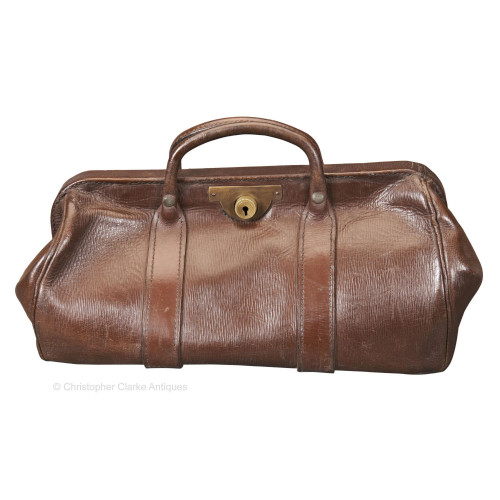
A leather Cased Set of England and Wales Batholomew Maps with a milometer.
The 37 Maps were produced by Sifton, Praed and Co. Ltd of The Map House, 67 St. James's Street London S.W.1 as noted to the back of each map. The company was founded in 1907 by Alfred Sifton and Francis Praed and are still in business today. The milometer is marked Depose to the back showing that it was imported from France.
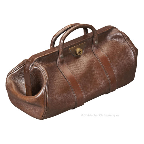
The case has two dividers to the interior to hold the maps in 3 banks numbered to the case from 1 to 12, 13 to 25 and 25 to 37. Each bank has a ribbon of cotton webbing fixed to the back and long enough to run the height of the back, under the maps and up the front. The maps are a tight fit to their compartments but when the ribbon is lifted, all the maps in the bank can be raised for easy access. The milometer is fitted to the interior of the lid. The lid has two locks with slide release buttons so that they can be locked without the keys. The original keys on their string remain so that the case can also be securely locked.
It is likely that the owner of this cased set of maps replaced some with updated versions over time. Some are ink marked to the front with dates ranging from 1930 to 1937 whilst others are pencil dated 1957. The maps from the 1950s are also dated in print by the manufacture with dates from November 1953 to May 1956. The later maps are mostly taller but still fit within the case height. Those unmarked, which are probably original to the case, can be dated to prior to 1921 as they have no road numbers, which were introduced at that date. They can also be dated to after 1911 from the addition of the Cyclist's Touring Club logo, which was the year they were formed.
Maps 18 to 20 and 24 have corrected printing errors to their numbers. Map 18 is printed as 19 to the interior with a correction label covering the number to the front. 19 and 20 are marked as 20 and 21 respectively to the interior but the number is correct to the cover. Map 24 is printed as 14 to the interior with a correction label to the cover. These corrections were all made by the publishers.
A number of the maps are trimmed to the bottom or top edge. However, the cover boards are not trimmed and in the correct position showing that it was done at the time of manufacture. The scale to all the maps is 2 Miles to an inch. Presumably, the size of some maps had to be bigger than others to give a more natural break point. In such cases there was less space to play with so edges had to be trimmed. We have seen such trimming on other sets.
The maps are backed on cloth with green cover boards giving an index to the sheet numbers. The pigskin leather case has a good fishtail carrying handle which is padded for comfort.
The owner of these maps obviously used them over a long period of time and probably updated those that they used the most or perhaps had major changes, to keep them relevant. For a motorist or cyclist they would have been invaluable. The set can be dated to circa 1920 but the replaced maps up to May 1956.
Case size is given.
Dimensions:
Circa 1920 with additions from the 1930s and 1950s.
Leather Case. Cloth backed printed maps
England. Milometer is French
Sifton, Praed and Co. Ltd and various other details
Motorists Maps
Good. Some maps updated over time
RELATED ITEMS


